What is happening with this low near the South Carolina and North Carolina is proof that it doesn’t need to have a name to cause major problems. Radar estimates and volunteer rain gages are showing over 15 inches of rain may have fallen in Carolina Beach, NC. Here are some posts from X showing the proof.
Life-threatening flash flooding is ongoing in Carolina Beach where volunteer rain gauges and radar are estimating over 15 inches of rain may have fallen.
Thanks to Debbie Hart Van Niman, Laura Graff, and Pete Hancock for providing these photos to us. #ncwx pic.twitter.com/jOso78YBNgAdvertisement— NWS Wilmington, NC (@NWSWilmingtonNC) September 16, 2024
Another look at the flooding at Carolina Beach. Photo by John Viano. #ncwx #WeatherOnThe1s @SpecNews1ILM pic.twitter.com/MvR24EyCvI
— Lee Ringer (@LeeRingerWx) September 16, 2024
Per the latest update from the National Hurricane Center, the low is centered 70 miles SSW of Cape Fear, NC with max winds at 50 mph. It is moving NNW at 5 mph. The low is poised to pull inland through tonight and drift through the Carolinas through mid-week.
Flooding rain is one of the main threats from this system. Here is the storm surge forecast for a few locations:
South Santee River, SC to Oregon Inlet, NC… 1-3 ft
Neuse and Bay Rivers, NC… 1-3 ft
Pamlico and Pungo Rivers, NC… 1-3 ft
There is also an isolated tornado threat across eastern North Carolina. We have already had a few warnings this morning.
The low has not become very defined and has not really organized. It is running out of time to really get organized and become a tropical or subtropical cyclone. At this point, it does not matter. The impacts will not change, flooding rains due to the persistent will be the rule and eventually spread more inland.
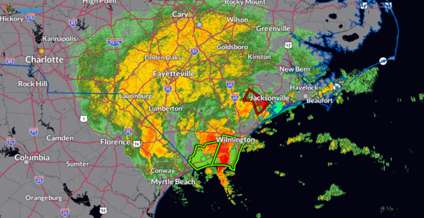
Here is the latest radar out of Wilmington, NC. Green polygons show active flash flood warnings and the red is an active tornado warning.
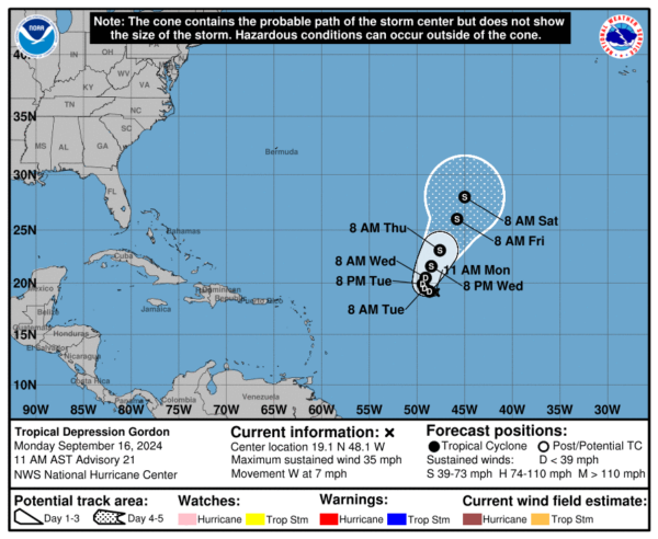
Gordon is hanging in there like a rusty fish hook. Thank you Bill Murray for that saying 🙂
Here are the latest stats:
LOCATION…19.1N 48.1W
ABOUT 985 MI…1580 KM E OF THE NORTHERN LEEWARD ISLANDS
MAXIMUM SUSTAINED WINDS…35 MPH…55 KM/H
PRESENT MOVEMENT…W OR 270 DEGREES AT 7 MPH…11 KM/H
MINIMUM CENTRAL PRESSURE…1006 MB…29.71 INCHES
Little change in strength forecast for the next 48 hours.
Category: ALL POSTS, Social Media, Tropical
(Except for the headline, this story has not been edited by PostX News and is published from a syndicated feed.)


