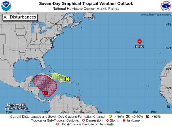
Tropical Storm Patty is moving through the eastern Azores late tonight with winds of 60 mph. It is expected to become a post tropical low Sunday night or Monday.
Next on our radar is Invest 97-L over the western Caribbean. Low pressure is expected to form between the Caymans and Jamaica on Monday. It will become a tropical storm and hurricane, crossing over Cuba on late Tuesday night and Wednesday morning, entering the southeastern Gulf of Mexico.
The system will move west northwest into the Central Gulf Wednesday and Thursday, slowly weakening as it goes due to wind shear.
An approaching frontal system will likely turn the system northward by late in the week. It may even dissipate before reaching the coast over the weekend. But it could enhance rainfall over Alabama by Saturday which would be great news for our current drought conditions.
Category: Alabama’s Weather, ALL POSTS, Social Media, Tropical
About the Author (Author Profile)
Bill Murray is the President of The Weather Factory. He is the site’s official weather historian and a weekend forecaster. He also anchors the site’s severe weather coverage. Bill Murray is the proud holder of National Weather Association Digital Seal #0001 @wxhistorian
(Except for the headline, this story has not been edited by PostX News and is published from a syndicated feed.)

