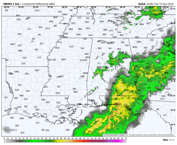
RADAR CHECK: Rain is widespread across Southeast Alabama this afternoon… large areas of rain are also over some of the northern and central counties. Temperatures are mostly in the 60s.
Rain will end across the state tonight as a cold front moves on to the east; temperatures will hold in the 67-72 degree range through the day.
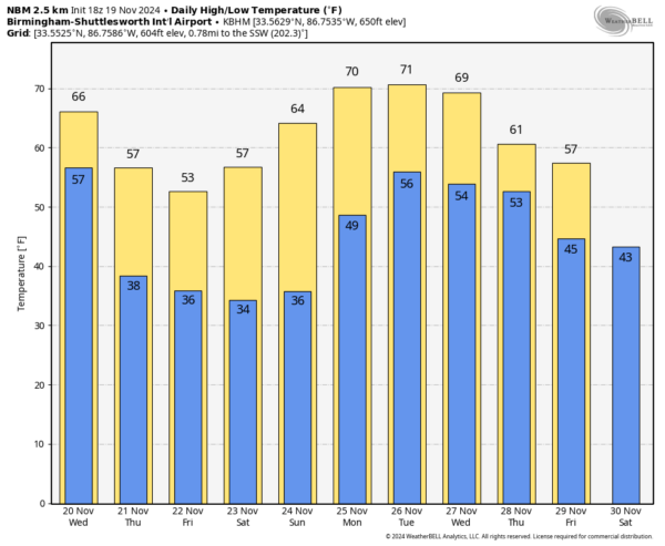
REST OF THE WEEK: The weather will be dry with a cooling trend. The high tomorrow will be back in the upper 60s and low 70s, but on Thursday highs across North Alabama drop into the 50s with a brisk north wind. Temperatures won’t get out of the 40s over parts of North Alabama Friday as the cold air continues to roll into the Deep South. Temperatures will be in the 30s early Friday across most of the state.
THE WEEKEND: The coldest morning will come early Saturday… many communities across North Alabama will see a freeze, and frost is likely deep into South Alabama. Look for a sun filled sky both days… the high Saturday will be in the 50s and 60s, followed by 60s statewide Sunday.
THANKSGIVING WEEK: For now most of the state looks dry Monday and Tuesday, followed by unsettled weather over the latter half of the week. Looks like there will some risk of rain or storms on Thanksgiving/Thursday, but it is too early for a specific forecast. See the video briefing for maps, graphics, and more details.
TROPICS: The Atlantic basin is very quiet, and tropical storm formation is not expected for at least the next seven days. Hurricane season ends in eleven days.
FOOTBALL WEATHER: The weather will be clear and cold for the high school playoff games Friday night. A clear sky with temperatures falling through the 40s, possibly reaching the 30s by the fourth quarter.
Saturday UAB will host Rice at Protective Stadium (1:00p CT kickoff)… the sky will be sunny with temperatures in the mid 50s.
Auburn hosts Texas A&M at Jordan-Hare Stadium (6:30p CT kickoff)… it will be a clear, cold evening in Lee County with temperatures falling through the 40s.
Alabama will be on the road; they take on Oklahoma in Norman (6:30p CT kickoff)… expect a clear sky with temperatures in the 50s.
ON THIS DATE IN 1930: An estimated F4 tornado struck the town of Bethany, Oklahoma. Between 9:30 am and 9:58 am CST, it moved north-northeast from 3 miles west of the Oklahoma City limits, and hit the eastern part of Bethany. About 110 homes and 700 other buildings, or about a fourth of the town, were damaged or destroyed. Near the end of the damage path, 3.5 miles northeast of Wiley Post Airfield, the tornado hit the Camel Creek School. Buildings blew apart just as the students were falling to the floor and looking for shelter, and five students and a teacher were killed. A total of 23 people were killed and another 150 injured, with 77 being seriously injured.
Look for the next video briefing here by 6:00 a.m. tomorrow…
Category: Alabama’s Weather, ALL POSTS, Weather Xtreme Videos
(Except for the headline, this story has not been edited by PostX News and is published from a syndicated feed.)


